|
A Day Hike in New Hampshire's White Mountains |
|---|
This day hike involved going along the Whitehouse Trail to the Liberty Springs Trail to the Franconia Ridge Trail to the summit of Mount Liberty:
Click here to view a topo map showing the trail.
The parking area for the Whitehouse and Liberty Springs Trails is located just north of the parking area for the Flume Visitors Center. Look for a sign that says "Liberty Springs". You can also park at the Flume Visitor Center and take the bicycle path to where the Liberty Springs Trail starts but this will add a little distance.
The Whitehouse Trail intersects the bicycle path at about 0.7 miles and after another 0.2 miles or so arrives at the trailhead for Liberty Springs. Look for a sign marking the trailhead on your right. Like most trails in the White Mountains this one spends a lot of time in the forest. You never get above the tree line at all on the Liberty Springs Trail and even most of the portion along the Franconia Ridge Trail, along the saddle between Little Haystack Mountain and Mount Liberty, is wooded. You will not break out of the trees until the final 0.1 miles to the summit of Mount Liberty.
I didn't check the time when I started up the Whitehouse Trail from the parking lot but it was just after 8 am when I started up the Liberty Springs Trail. From the start of the Liberty Springs Trail it is about 1 mile to a series of stream crossings, one of these being quite wide and having a good flow. Shortly after the final stream crossing the trail takes a sharp right-hand turn towards the north-east and begins its ascent to the Liberty Springs Campsite and Franconia Ridge. This section of the trail can be brutal as it just seems to go up forever. There are no switchbacks at all to ease the climb and the trail just goes straight up the side of the ridge. The climb goes on for about a mile and at the end of that you will be at the Liberty Springs Campsite. There is a reliable water source here (marked) a short distance off to the right of the trail. The water does not need to be treated and tastes wonderful. No permit is required for camping but you must register with the ranger.
From the Liberty Springs Campsite the trail climbs more gradually for another 0.3 miles to its junction with the Franconia Ridge Trail. Take a right turn on the Franconia Ridge Trail to head south ot the summit of Mount Liberty. Heading north will take you to Little Haystack Mountain and the Falling Waters Trail, and beyond that Mount Lincoln and Lafayette and the Old Bridle Path. The trees along the ridge are considerably thinned out compared to the dense forest below and the trail here is fairly level and clear of debris.
|
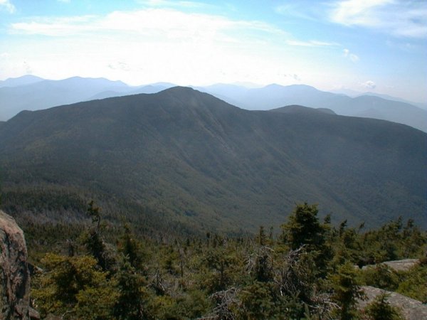
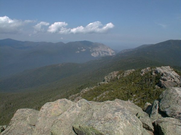
When I was up there I was blessed fantastic day, mostly clear with just a few puffy clouds and relatively cool. I reached the summit at just after 10 am and remained there until just after 11 am. There was no one else up there and I relished in having the place to myself. The summit area is very small and cluttered with numerous large cairns. I found a nice spot to sit down, overlooking Franconia Notch and the valley below. Mount Lincoln and Little Haystack Mountain dominated the view to the north and Mount Flume to the south.
Just as I was getting ready to depart another solo hiker appeared on the summit and we talked briefly before I began the descent. He had come up the Flume Slide Trail and then across the ridge from Mount Flume. I tried going down this trail once but was turned back by the sheer steepness of it. The "slide" part of the name is very appropriate. The trail is more commonly used for ascents and these can also be treacherous, especially if the ledges are wet, which they were today.
|
On my way back down the trail I stopped briefly at the spring (Liberty Spring?) near the Libery Springs Campsite to replenish my water supply. The water comes out of a pipe in the rock and was nice and cold and tasted wonderful.
From the spring, and beyond the camping area, the trail heads downward at an unbelievable angle. I stopped a couple of times just to drink water and give my knees a break from the constant pounding. During one of these stops are fairly large toad hopped across the trail and then just disappeared into the undergrowth along the other side. He was very well camoflagued but after a little searching I finally located him again and took a picture.
I was very happy to finish that steep downward portion of the trail which, like the hike up, seemed to go on forever. When the trail suddenly took a sharp turn towards the north I knew it was over. I crossed over numerous streams again on the way back to the trailhead and some of these looked very beautiful with the sunlight glinting off of the water. I finally arrived back at my car at just after 1 pm.
|
|
|
|---|
|
|---|


